
Understanding Metadata in Subsea Imaging
TL;DR: Metadata transforms underwater video from raw visuals into reliable, traceable data. By embedding information such as time, depth, and position directly into each frame, subsea teams can verify accuracy, speed up analysis, and build a consistent record of conditions over time.
In subsea imaging, picture quality is only half the story. Without context (i.e., where, when, and under what conditions the footage was captured), an image is just a snapshot. Metadata provides that context.
Metadata is the information embedded within each image or video frame that describes the conditions and settings at the time of capture. For underwater operations, this includes details such as GPS coordinates, depth, altitude, camera settings, and time. Together, these data points transform underwater visuals into verifiable datasets that engineers, operators, and researchers can trust.
For inspection, research, and defence applications, metadata has become as essential as the imagery itself. It provides the foundation for data integrity, repeatability, and long-term value in underwater observation.
What’s Captured in Underwater Imaging Metadata
Many subsea camera captures more than what’s visible through the lens. Today’s imaging systems record a rich layer of information that accompanies each frame, including:
Positional data – GPS coordinates, heading, depth, and altitude
Temporal data – precise timestamps, frame rates, and capture intervals
Environmental data – water temperature, salinity, turbidity, or other sensor inputs
System data – exposure, focus, gain, bitrate, and camera mode
Modern underwater cameras embed this information directly into image or video files using standardized metadata formats such as EXIF (Exchangeable Image File Format). This ensures that key details like time, position, and camera settings, remain stored within the file itself, even when data is transferred or processed later. By eliminating the need for manual note-taking, metadata ensures information stays synchronized and accessible across devices. When an operator or researcher revisits a file, they can immediately understand the conditions under which it was recorded.

EXIF metadata from a Rayfin camera showing embedded GPS, time, and image settings for accurate post-processing and data validation.
Enhancing Accuracy and Repeatability
Metadata lets teams do something that was once difficult in subsea work: repeat an exact measurement, view, or inspection years later.
For offshore operators, this means returning to the same weld or structure with precision for integrity checks. For marine researchers, it enables monitoring of a single habitat or seafloor feature over time. The positional and temporal data embedded in each frame make it possible to align new imagery with past datasets, ensuring accurate change detection and documentation.
This repeatability improves efficiency and reliability across disciplines, from offshore energy inspections to long-term ecological studies. It also supports integration with complementary datasets such as sonar, LiDAR, and mapping systems, allowing for richer cross-referenced insights.
Streamlining Post-Processing and Analysis

Using metadata, you can create a map of ROV dive locations.
When metadata is embedded within the original files, it simplifies how footage is managed, analyzed, and reported.
Operators can automatically sort and search files by dive number, date, or location, saving hours in manual organization. During playback, metadata overlays can display time, depth, or heading, allowing users to interpret footage in context without switching between separate logs.
In more advanced workflows, metadata is also used to speed up post-processing tasks such as 3D reconstruction, photogrammetry, or machine learning. Having synchronized timestamps and position data allows software to align images precisely, creating accurate 3D models and maps of subsea assets or environments.
The result is a streamlined process that reduces human error, shortens reporting timelines, and improves overall data quality.
Ensuring Data Integrity and Traceability
In industries where underwater data supports regulatory compliance or mission-critical operations, the ability to verify and trace information is essential. Metadata provides that assurance.
By embedding timestamps, positional data, and device identifiers directly within each file, metadata establishes a verifiable chain of custody for imagery. This traceability is critical when footage is used for inspection reports, environmental submissions, or defence documentation.
In subsea asset integrity management, metadata ensures that visual evidence i.e. video and stills, aligns with dive logs and operational records. For scientific archives, it guarantees that data remains consistent and comparable across time. And in defence applications, it helps validate authenticity, ensuring operators can trust both the content and its source.
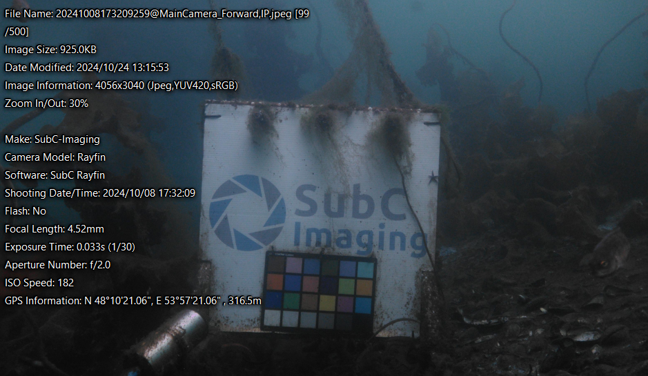
Underwater image captured by a SubC Rayfin camera showing a calibration target and on-screen metadata including GPS coordinates, time, and camera settings.
Integrating Metadata Across Underwater Systems
The role of metadata is expanding as underwater systems become more connected. Integrated platforms, such as SubC Imaging’s Rayfin cameras and DVR+ Overlay system, synchronize metadata across multiple sensors, combining video, audio, positional, and environmental inputs into one seamless dataset.
This integration supports emerging needs such as:
Real-time streaming and remote operations – transmitting live video with synchronized metadata for situational awareness and decision-making from shore.
Automated event tagging – identifying and labeling points of interest during recording for faster review later.
Cloud-based data management – archiving large volumes of metadata-rich imagery for ongoing analysis and AI-assisted insights.
As subsea operations become more automated and distributed, metadata will remain the common thread connecting data integrity, operational context, and long-term understanding of underwater environments.
Turning Images into Insight
Metadata transforms underwater imaging from simple observation to actionable intelligence. It ensures that every frame is anchored by reliable information: where it was captured, when it was taken, and under what conditions.
For operators, researchers, and system builders, this means better data continuity, faster analysis, and more confident decisions in the field.